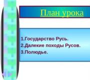
Drawings of traffic rules signs. Traffic signs for children with explanations
The baby grows and strives to explore the world around him, becoming more inquisitive. Let's use this natural curiosity to teach a child how to behave safely on the street, and especially on the road. Of course, you need to start with yourself and review your behavior on the road. Very often we, parents, ignore road signs and basic self-preservation instincts and run across the road, thereby setting a bad example for our child. It would seem that there is a traffic light or a road sign prohibiting crossing in this place, but no one cares... Despite the fact that the state is implementing various programs aimed at improving road safety in the country, tens of thousands of Russians die under the wheels of cars. The statistics on road accidents involving children are simply terrifying. And parents are largely to blame for this situation because they did not show their children traffic signs in time and did not teach them to follow road safety rules.
The Your Child website has prepared this material for parents and teachers, in which we will tell you about the most important road signs so that you can convey this, as it turns out, vital information to your children.
In general, road signs are divided into several categories, with a total of several hundred of them, which, you see, is too many even for a child’s inquisitive mind. Therefore, from each category we will select only those signs that are found most often in any locality.
| The first sign that occurs very often is pedestrian crossing sign. This sign indicates an uncontrolled pedestrian crossing, that is, one where there is neither a traffic light nor a traffic controller. It seems very important to tell the child that you need to cross the road only in the place where there is this road sign. | |
 |
Second sign- underground pedestrian crossing sign, informs about the availability of this convenient way to cross the road. There is another sign indicating a land crossing, in which a person goes up. It is worth explaining to your child that an underground (or overground) pedestrian crossing is a safe way to cross the road and should be used. |
 |
The third sign is called "Bus or trolleybus stop", it indicates the place where a public transport stop is organized. The child should be reminded that playing within the coverage area of this road sign, and especially running onto the roadway, is strictly prohibited! |
 |
The fourth sign is found most often in courtyards, it is called "Living sector", and also in the picture there is another sign “End of residential area”. In the area covered by the “Residential Zone” sign, drivers are required to give way to pedestrians. But despite this formal requirement of traffic rules, accidents with children occur in courtyards. There are several reasons for this - the driver’s inexperience, his fatigue, but the children themselves can also be to blame. Teach your child not to run out onto the road located in the yard, to be more careful and circumspect. |
 |
The fifth sign is called "Pedestrian zone". It means that the movement of all vehicles is prohibited. It is safe for a child to play in this area, but nevertheless it is worth remembering about reckless drivers in cars for whom the rules of the road are simply not written. Teach your children to correctly assess the situation and be prepared for the unexpected. |
 |
The sixth sign does not directly affect the safety of a child on the road, but it occurs very often, especially at intersections. This sign is called "Driving directions by lane". The purpose of this sign is to indicate the number of lanes before the intersection and indicate the direction of movement along each of the lanes. |
Let's move on to the second category of road signs, which is called "Warning Signs". It seems that these signs are only needed by drivers, but pedestrians also need them. Let's see what signs are in this category. Not all signs will be described below, but only those that are more common and will be of interest to our children.
 |
The first sign is called "Railway crossing with barrier", it is designed to inform drivers about an upcoming railway crossing. Children should be explained that being near a railway crossing, much less playing on it, is very dangerous. |
 |
There is a variation of the above sign called " Railway crossing without barrier". Everything said above directly applies to this sign. |
 |
The next sign is called "Artificial hump". Why is it needed? It is needed precisely to create safe conditions for pedestrian traffic. Drivers, seeing this sign, know that there will be a bump on the road, they are forced to slow down. |
The next group of signs is service signs. They do not directly affect the child’s safety on the road, but inquisitive children ask a lot of questions when they see them on the road.
 |
Let's start getting acquainted with this group of road signs with gas station sign. This sign indicates that a gas station is located nearby, and how far it is located is indicated by the numbers under the sign. In the example given, the gas station is located at a distance of 800 meters. |
 |
Next sign - "Car maintenance". It tells the driver how far away the service center is and where a technical problem with the car can be repaired. The number on the sign indicates the distance to the service in meters. |
 |
The third sign of this category, which raises many questions among the younger generation, is car wash sign. Indicates a place where car owners can wash their dirty car. |
Here's a review of traffic signs we did. Of course, we didn’t look at all the signs, because there are several hundred of them, but we tried to describe those signs that are of the greatest interest to children and, most importantly, have a direct impact on their safety on the roads.
Even if you are not a driver and such a joyful event as obtaining a driver’s license is not expected in the near future, knowledge of road signs will not be superfluous. Moreover, they form an important part of the rules of the road traffic system and apply equally to all its participants.
Basically, road signs are presented in the form of standardized graphic designs and are located either along roads or in places with a large number of people, for example, in a pedestrian crossing or subway. In addition, these are the main assistants in correct orientation on the roads and in the area.
Classification of road signs
The structure of road signs is clearly systematized and divides signs into eight groups, depending on their functions and semantic community.
So, the main types of signs are:
- warning;
- priority;
- prohibiting;
- prescriptive;
- particularly prescriptive;
- informational and indicative;
- service;
- additionally informative.
Each of these groups has its own characteristics and specific application.
- Warning signs. Shape: red triangle with white background. Well visible from afar. These signs are the safest and most useful because they are not restrictive or prohibitive. Their main function is notification of dangerous sections of the road, the nature of the potential threat and traffic difficulties, and warning against road accidents. Numbering starts with the number “1”.
- Priority signs. They come in different shapes and colors. There are only thirteen of them and therefore do not cause difficulties in remembering. A feature of priority signs is the determination of the priority right to cross roadways, intersections and narrow sections of roads. This group of signs includes: main road, movement without stopping is prohibited, priority of oncoming traffic, etc. Numbering starts with the number “2”.
- Prohibition signs. Mostly round in shape with a black pattern on a white background and a serial number of category “3”. Meaning: prohibition of certain actions on the road, introduction or cancellation of traffic restrictions. The most famous: “brick” (entry prohibited), prohibition of parking or stopping, overtaking, speed limit, etc.
- Mandatory signs. Also round in shape, but with white designs on a blue field. Group numbering starts with the number “4”. Function: indicating the direction of movement on certain sections of the road, limiting the minimum speed, warning about subsequent prohibition signs.
- Special instructions signs. Group numbering starts with "5". Few, but very significant. They combine elements of prohibitory and prescriptive signs. Meaning: entering or canceling certain traffic modes, adjusting one-way traffic flow, designating a residential area, pedestrian crossing, priority of road lanes, and so on. Fines for violating these sign requirements directly depend on their type and range.
- Information and directional signs. In the shape of a square or rectangle with a blue border and a white/black design on a blue/white background. The group serial number is “6”. Responsible for informing all road users about populated areas, the nature of the road, the location of transport lanes, established travel modes and related recommendations.
- Service marks. The shape and color are the same as the information ones. The numbering starts with the number “7”. Function: information about various services and facilities - hotels, gas stations, campsites, cafes, etc. Signs are located at turns to the service location or directly next to them. Like category “6” signs, service signs also have exclusively informative meaning.
- Additional information signs. Presented in the form of rectangular plates with a black border and a pattern on a white background. The main purpose is to complement and clarify the actions of road signs from other categories. Never used on their own.
Road and children
With the help of this video, your child will be able to learn all the traffic signs.
A separate issue is to familiarize the child with the traffic rules. After all, as you know, traffic rules are not written for children and they think little about their own safety while moving across the road. This is why teaching them basic road signs from an early age is so important.
A truly children's sign warning of their appearance from the territory of an educational and similar institution adjacent directly to the road is the sign "Careful, children!"
It belongs to the warning group and should be taken into account not only by drivers, but also by children themselves, telling them that crossing the road in a given place is prohibited. In addition, similar stickers are used on public transport intended for transporting children.
Other most common signs for children are:
Sign "Crosswalk" with a depicted zebra on it and indicating the location of the overpass of the roadway. However, the same sign, but in a red triangle, acts as a warning to the driver about approaching the crossing and the need to reduce speed. For a pedestrian, this is a clear signal that crossing the road at the location of the sign is prohibited.
Sign "Underground pedestrian crossing". It is installed at the entrance near the crossing, indicating the place of safe crossing of the street underground.
Sign “Tram/bus stop location”. Informs about the location of public transport stops and passengers' expectations.
Sign "Footpath". Indicates a road intended for pedestrians only. The general rules of behavior for pedestrians apply.
Sign "No Pedestrians". The name of the sign speaks for itself. Installed in places where traffic may be unsafe. Often used to temporarily restrict movement.
Sign "Bike Lane" clearly indicates the road exclusively for bicycles and mopeds. Moving other types of transport here is strictly prohibited. In addition, this road can also be used by pedestrians, in the absence of a sidewalk.
Sign "Bicycles are prohibited". It speaks of the impossibility of using a bicycle for movement in this place. There is danger for cyclists on the road. When introducing a child to the principles of traffic and signs, it is necessary to pay great attention to the rules of behavior in public places, when crossing the street, waiting for transport, etc.
After all, extra vigilance is a sure guarantee of his safety!
Warning signs and their meaning
The table shows the warning signs that are most often found in urban areas.
| SIGN | NAME | MEANING |
|---|---|---|
| "Crosswalk" | The possibility of a pedestrian appearing on the roadway. The need to reduce speed. Warning for crossing at a given point in the street. |
|
| "Children" | Possibility of sudden appearance of children on the road. | |
| "Men at work" | Carrying out repair or construction road work. Probability of special. technicians, workers, holes, potholes, etc. | |
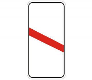
| "Railway crossing with barrier" | Designation of the location of the barrier when crossing the roadway with railway tracks. | |
| "Railway crossing without a barrier" | Absence of a barrier at the intersection of the roadway with railway tracks. Additional attention should be paid when drivers and pedestrians cross the crossing. | |
| "Dangerous Turns" | There are several dangerous turns on the road. The bend of the line indicates the direction of the turns. | |
| "Rough road" | There are various irregularities, potholes, holes, etc. on the road. | |
| "Slippery road" | Slippery roads due to sleet, ice, rain or wet leaves. | |
| "Ejection of rocky materials" | Possibility of gravel, crushed stone, etc. being thrown out from under the wheels of a vehicle due to poor-quality road surface. | |
| "Emergency area" | Various types of danger on this section of the road. | |
| "Traffic Congestion" | Possibility of congestion and traffic jams in the area covered by this sign. | |
| "Rotation direction" | Warning about very sharp turns on the road. The direction of the arrows indicates the orientation. |
In addition, there are two special warning signs used in areas where there are embankments and bridges.
SIGN NAME MEANING
It should be remembered that ignorance of traffic rules does not relieve either drivers or pedestrians from responsibility. The latter, in case of traffic violations, are also subject to a fine.
Therefore, it is better to prevent such unpleasant situations and study the road rules and signs.
Road signs that are in force on the roads in 2018:
1.2 “Railway crossing without a barrier.”
1.3.1 “Single-track railway”.
1.3.2 "Multi-track railway".
Designation of a railway crossing not equipped with a barrier: 1.3.1 - with one track, 1.3.2 - with two tracks or more.


 1.4.1 - 1.4.6 “Approaching a railway crossing.” Additional warning about approaching a railway crossing outside of populated areas.
1.5 "Intersection with a tram line."
1.6 “Intersection of equivalent roads.”
1.7 "Roundabout intersection".
1.8 “Traffic light regulation”. An intersection, pedestrian crossing or section of road where traffic is regulated by a traffic light.
1.9 "Drawbridge". Drawbridge or ferry crossing.
1.10 “Departure to the embankment.” Departure to the embankment or shore.
1.11.1, 1.11.2 “Dangerous turn.”
1.12.1, 1.12.2 - “Dangerous turns”.
A section of the road with dangerous turns: 1.12.1 - with the first turn to the right, 1.12.2 - with the first turn to the left.
1.13 “Steep descent.”
1.14 “Steep climb.”
1.15 "Slippery road." A section of road with increased slipperiness of the roadway.
1.16 "Rough Road" A section of road that has unevenness on the roadway (undulations, potholes, uneven junctions with bridges, etc.).
1.17 “Artificial hump”. A section of road with artificial hump(s) to force a reduction in speed.
1.18 "Gravel release". A section of road where gravel, crushed stone and the like can be thrown out from under the wheels of vehicles.
1.19 "Dangerous roadside." A section of road where pulling off to the side of the road is dangerous.
1.20.1 - 1.20.3 “Narrowing of the road.”
Tapering on both sides - 1.20.1, on the right - 1.20.2, on the left - 1.20.3.
1.21 “Two-way traffic”. The beginning of a section of road (roadway) with oncoming traffic.
1.22 “Pedestrian crossing”. Pedestrian crossing marked with signs 5.19.1, 5.19.2 and (or) markings 1.14.1 and 1.14.2.
1.23 "Children". A section of road near a children's institution (school, health camp, etc.), on the roadway of which children may appear.
1.24 “Intersection with a bicycle path.”
1.25 “Road works”.
1.26 “Cattle Driving.”
1.27 "Wild Animals".
1.28 “Falling Stones.” A section of road where avalanches, landslides, and falling rocks are possible.
1.29 "Sidewind".
1.30 "Low-flying planes."
1.31 "Tunnel". A tunnel in which there is no artificial lighting, or a tunnel in which the visibility of the entrance portal is limited.
1.32 "Congestion". A section of road where there is a traffic jam.
1.33 "Other hazards." A section of road that contains hazards that are not indicated by other warning signs.

 1.34.1, 1.34.2 “Rotation direction”. Direction of movement on a curved road of small radius with limited visibility. Direction to bypass the road section being repaired.
![]() 1.34.3 "Rotation direction". Driving directions at a T-junction or fork in the road. Directions to bypass the road section being repaired.
1.34.3 "Rotation direction". Driving directions at a T-junction or fork in the road. Directions to bypass the road section being repaired.
2. Priority signs
2.1 "Main Road". A road on which the right of way is granted to unregulated intersections.
2.2 "The end of the main road."
2.3.1 “Intersection with a secondary road.”
2.3.2 - 2.3.7 “Adjunction of a secondary road.”
Adjacent to the right - 2.3.2, 2.3.4, 2.3.6, to the left - 2.3.3, 2.3.5, 2.3.7.
2.4 " ". The driver must give way to vehicles moving on the road being crossed, and, if there is a sign 8.13, on the main road.
2.5 “Driving without stopping is prohibited.” It is prohibited to drive without stopping in front of the stop line, and if there is none, in front of the edge of the roadway being crossed. The driver must give way to vehicles moving along the intersection, and if there is a sign 8.13 - on the main road.
Sign 2.5 can be installed in front of a railway crossing or quarantine post. In these cases, the driver must stop in front of the stop line, and if there is no stop line, in front of the sign.
2.6 “Advantage of oncoming traffic.”
It is prohibited to enter a narrow section of road if this may impede oncoming traffic. The driver must give way to oncoming vehicles located in a narrow area or the opposite entrance to it.
2.7 "Advantage over oncoming traffic."
A narrow section of road on which the driver has advantage over oncoming vehicles.
3. Prohibition signs
Prohibition signs introduce or remove certain traffic restrictions.
3.1 “Entry is prohibited.” Entry of all vehicles in this direction is prohibited.
3.2 “Movement is prohibited.” All vehicles are prohibited.
3.3 “The movement of motor vehicles is prohibited.”
3.4 “Truck traffic is prohibited.”
The movement of trucks and vehicle combinations with a permissible maximum weight of more than 3.5 tons (if the weight is not indicated on the sign) or with a permissible maximum weight more than indicated on the sign, as well as tractors and self-propelled vehicles is prohibited.
3.5 “Motorcycles are prohibited.”
3.6 “Movement of tractors is prohibited.” The movement of tractors and self-propelled vehicles is prohibited.
3.7 “Moving with a trailer is prohibited.”
It is prohibited to drive trucks and tractors with trailers of any type, as well as tow motor vehicles.
3.8 “The movement of horse-drawn carts is prohibited.”
The movement of horse-drawn carts (sleighs), riding and pack animals, as well as the passage of livestock is prohibited.
3.9 “Bicycles are prohibited.” Bicycles and mopeds are prohibited.
3.10 “Pedestrian traffic is prohibited.”
3.11 “Weight limitation”.
The movement of vehicles, including combinations of vehicles, the total actual weight of which is greater than that indicated on the sign, is prohibited.
3.12 “Limitation of mass per vehicle axle.”
It is prohibited to drive vehicles whose actual weight on any axle exceeds that indicated on the sign.
3.13 "Height limitation".
The movement of vehicles whose overall height (with or without cargo) is greater than that indicated on the sign is prohibited.
3.14 "Width limitation". It is prohibited to drive vehicles whose overall width (laden or unladen) is greater than that indicated on the sign.
3.15 "Length limitation".
The movement of vehicles (vehicle trains) whose overall length (with or without cargo) is greater than that indicated on the sign is prohibited.
3.16 “Minimum distance limitation.”
It is prohibited to drive vehicles with a distance between them less than that indicated on the sign.
3.17.1 “Customs”. It is prohibited to travel without stopping at a customs office (checkpoint).
3.17.2 "Danger"
The further movement of all vehicles without exception is prohibited due to a traffic accident, accident, fire or other danger.
3.17.3 "Control". Driving through checkpoints without stopping is prohibited.
3.18.1 “Right turns are prohibited.”
3.18.2 “Left turns are prohibited.”
3.19 “Turning is prohibited.”
It is prohibited to overtake all vehicles except slow-moving vehicles, horse-drawn carts, mopeds and two-wheeled motorcycles without sidecars.
3.21 “End of the no-overtaking zone.”
3.22 “Overtaking by trucks is prohibited.”
It is prohibited for trucks with a permissible maximum weight of more than 3.5 tons to overtake all vehicles.
3.23 “End of the no-overtaking zone for trucks.”
3.24 “Maximum speed limit.”
It is prohibited to drive at a speed (km/h) exceeding that indicated on the sign.
3.25 “End of maximum speed limit zone.”
3.26 “Sound signal is prohibited.”
It is prohibited to use sound signals, except in cases where the signal is given to prevent a traffic accident.
3.27 “Stopping is prohibited.” No vehicles allowed.
3.28 “Parking is prohibited.” Parking of vehicles is prohibited.
3.29 “Parking is prohibited on odd days of the month.”
3.30 “Parking is prohibited on even days of the month.”
When signs 3.29 and 3.30 are used simultaneously on opposite sides of the roadway, parking is permitted on both sides of the roadway from 19:00 to 21:00 (rearrangement time).
3.31 “End of the zone of all restrictions.”
Designation of the end of the coverage area simultaneously for several signs from the following: 3.16, 3.20, 3.22, 3.24, 3.26 - 3.30.
3.32 “The movement of vehicles with dangerous goods is prohibited.”
The movement of vehicles equipped with identification signs (information plates) “Dangerous cargo” is prohibited.
3.33 “The movement of vehicles with explosive and flammable cargo is prohibited.”
4. Mandatory signs
4.1.1 “Move straight ahead.”
4.1.2 “Move to the right.”
4.1.3 “Move to the left.”
4.1.4 “Move straight or to the right.”
4.1.5 “Move straight or left.”
4.1.6 “Movement to the right or left.”
Driving is permitted only in the directions indicated by arrows on the signs. Signs that permit a left turn also permit a U-turn (signs 4.1.1 - 4.1.6 with a configuration of arrows corresponding to the required directions of movement at a particular intersection can be used).
Signs 4.1.1 - 4.1.6 do not apply to route vehicles. The effect of signs 4.1.1 - 4.1.6 extends to the intersection of roadways in front of which the sign is installed. The effect of sign 4.1.1, installed at the beginning of a section of road, extends to the nearest intersection. The sign does not prohibit turning right into courtyards and other areas adjacent to the road.
4.2.1 “Avoiding obstacles on the right.”
4.2.2 “Avoiding obstacles on the left.” Detour is permitted only from the direction indicated by the arrow.
4.2.3 “Avoiding obstacles on the right or left.” Detour is permitted from any direction.
4.3 "Circular movement". Movement in the direction indicated by the arrows is permitted.
4.4 "Bicycle path".
4.5 "Pedestrian path". Only pedestrians are allowed to move.
4.6 “Minimum speed limit.” Driving is only permitted at the specified speed or higher (km/h).
4.7 “End of minimum speed limit zone.”
The movement of vehicles equipped with identification signs (information tables) “Dangerous Goods” is permitted only in the direction indicated on the sign: 4.8.1 - straight, 4.8.2 - right, 4.8.3 - left.
5. Signs of special regulations
Special regulations signs introduce or cancel certain traffic modes.
5.1 "Highway".
A road on which the requirements of the Road Traffic Rules of the Russian Federation apply, establishing the procedure for driving on highways.
5.2 "End of the motorway."
5.3 “Road for cars.”
A road intended for use only by cars, buses and motorcycles.
5.4 “The end of the road for cars.”
5.5 “One-way road.”
A road or carriageway along which vehicle traffic across its entire width is carried out in one direction.
5.6 "The end of a one-way road."
5.7.1, 5.7.2 “Entering a one-way road.” Entering a one-way road or carriageway.
5.8 "Reverse movement".
The beginning of a section of road where one or more lanes may change direction to the opposite direction.
5.9 “End of reverse movement.”
5.10 “Entering a road with reverse traffic.”
5.11 “Road with a lane for route vehicles.” A road on which the movement of route vehicles, cyclists and vehicles used as passenger taxis is carried out along a specially designated lane towards the general flow of vehicles.
5.12 “End of the road with a lane for route vehicles.”
5.13.1, 5.13.2 “Entering a road with a lane for route vehicles.”
5.14 “Lane for route vehicles.” A lane intended for the movement only of route vehicles, cyclists and vehicles used as passenger taxis moving in the same direction as the general flow of vehicles.
5.14.2 “Lane for cyclists” - a lane of the roadway intended for the movement of bicycles and mopeds, separated from the rest of the roadway by horizontal markings and marked with sign 5.14.2.
 5.15.1 “Traffic directions along lanes.”
The number of lanes and permitted directions of movement for each of them.
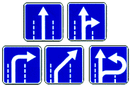 5.15.2 “Lane directions”.
Permitted lane directions.
Signs 5.15.1 and 5.15.2, which permit a left turn from the extreme left lane, also permit a U-turn from this lane.
Signs 5.15.1 and 5.15.2 do not apply to route vehicles. The effect of signs 5.15.1 and 5.15.2 installed in front of the intersection applies to the entire intersection, unless other signs 5.15.1 and 5.15.2 installed on it give other instructions.
 5.15.3 “Start of stripe”.
The beginning of an additional uphill or braking lane. If the sign installed in front of the additional lane displays sign(s) 4.6 “Minimum speed limit,” then the driver of a vehicle who cannot continue driving along the main lane at the indicated or higher speed must change lanes to the lane located to his right.
 5.15.4 “Start of stripe”.
The beginning of the middle section of a three-lane road intended for traffic in a given direction. If sign 5.15.4 shows a sign prohibiting the movement of any vehicles, then the movement of these vehicles in the corresponding lane is prohibited.
5.15.5 “End of lane”. The end of an additional uphill lane or acceleration lane.
5.15.6 “End of lane”.
The end of a section of the median on a three-lane road intended for traffic in a given direction.
If sign 5.15.7 shows a sign prohibiting the movement of any vehicles, then the movement of these vehicles in the corresponding lane is prohibited.
Signs 5.15.7 with the appropriate number of arrows can be used on roads with four or more lanes.
 5.15.8 “Number of lanes”.
Indicates the number of lanes and lane modes. The driver is obliged to comply with the requirements of the signs marked on the arrows.
5.16 “Bus and (or) trolleybus stopping place.”
5.17 “Tram stopping place.”
5.18 “Taxi parking area.”
5.19.1, 5.19.2 “Pedestrian crossing”.
If there are no markings 1.14.1 or 1.14.2 at the crossing, sign 5.19.1 is installed to the right of the road on the near border of the crossing relative to approaching vehicles, and sign 5.19.2 is installed to the left of the road on the far border of the crossing.
5.20 “Artificial hump”.
Indicates the boundaries of an artificial roughness. The sign is installed at the nearest boundary of the artificial hump relative to approaching vehicles.
5.21 “Residential area”.
The territory in which the requirements of the Road Traffic Rules of the Russian Federation are in force, establishing the rules of traffic in a residential area.
5.22 “End of the residential area.”
![]() 5.23.1, 5.23.2 “Beginning of a populated area.”
5.23.1, 5.23.2 “Beginning of a populated area.”
The beginning of a populated area in which the requirements of the Road Traffic Rules of the Russian Federation are in force, establishing the procedure for traffic in populated areas. ![]() 5.24.1, 5.24.2 “End of a populated area.”
5.24.1, 5.24.2 “End of a populated area.”
The place from which on a given road the requirements of the Road Traffic Rules of the Russian Federation, establishing the procedure for traffic in populated areas, cease to apply.
![]() 5.25 “The beginning of a settlement.”
5.25 “The beginning of a settlement.”
The beginning of a populated area in which the requirements of the Road Traffic Rules of the Russian Federation, which establish traffic rules in populated areas, do not apply on this road.
![]() 5.26 “End of a settlement.”
5.26 “End of a settlement.”
The end of a populated area in which the requirements of the Road Traffic Regulations of the Russian Federation, which establish traffic rules in populated areas, do not apply on this road.
5.27 “Zone with limited parking.”
The place from which the territory (section of the road) begins where parking is prohibited.
5.28 “End of restricted parking zone.”
5.29 “Regulated parking zone.”
The place from which the territory (section of the road) begins, where parking is permitted and regulated with the help of signs and markings.
5.30 “End of regulated parking zone.”
5.31 “Zone with maximum speed limit.”
The place from which the territory (section of the road) begins where the maximum speed is limited.
5.32 “End of zone with maximum speed limit.”
5.33 “Pedestrian zone”.
The place from which the territory (section of the road) begins where only pedestrian traffic is allowed.
5.34 “End of the pedestrian zone.”
6. Information signs
Information signs inform about the location of populated areas and other objects, as well as established or recommended traffic modes.
 6.1 “General maximum speed limits.”
General speed limits established by the Road Traffic Rules of the Russian Federation.
The speed at which it is recommended to drive on this section of the road. The sign's coverage area extends to the nearest intersection, and when sign 6.2 is used together with a warning sign, it is determined by the length of the dangerous area.
6.3.1 “Turning space.” Turning left is prohibited.
6.3.2 "Turning area". Length of the turning area. Turning left is prohibited.
6.4 “Parking location”.
6.5 "Emergency stop strip". Emergency stop strip on a steep descent.
6.6 “Underground pedestrian crossing.”
6.7 “Overground pedestrian crossing.”
6.8.1 - 6.8.3 "Deadlock". A road with no through passage.
6.9.1 "Advance directions"
 6.9.2 "Advance direction indicator".
Directions to the settlements and other objects indicated on the sign. Signs may contain images of the sign 6.14.1  , highway, airport and other pictograms. Sign 6.9.1 may contain images of other signs informing about traffic patterns. At the bottom of sign 6.9.1, the distance from the place where the sign is installed to the intersection or the beginning of the deceleration lane is indicated.
Sign 6.9.1 is also used to indicate a detour around sections of roads on which one of the prohibition signs 3.11 - 3.15 is installed.
6.9.3 “Traffic pattern”.
The route of movement when certain maneuvers are prohibited at an intersection or permitted directions of movement at a complex intersection.
 6.10.1 “Direction indicator”
 6.10.2 “Direction indicator”.
Driving directions to route points. The signs may indicate the distance (km) to the objects indicated on them, as well as symbols of a highway, airport and other pictograms.
 6.11 “Name of the object.”
The name of an object other than a populated area (river, lake, pass, landmark, etc.).
 6.12 “Distance indicator”.
Distance (km) to settlements located along the route.
 6.13 “Kilometer sign”. Distance (km) to the beginning or end of the road.
 6.14.1, 6.14.2 “Route number”.
6.14.1 - number assigned to the road (route); 6.14.2 - number and direction of the road (route).


 6.15.1 - 6.15.3 "Traffic direction for trucks."
![]() 6.16 "Stop line".
6.16 "Stop line".
The place where vehicles stop when there is a prohibiting traffic light signal ().
6.17 “Detour diagram”. Route to bypass a section of road temporarily closed to traffic.
Direction to bypass a section of road temporarily closed to traffic.
6.19.1, 6.19.2 “Preliminary indicator for changing lanes onto another roadway.”
The direction to bypass a section of the roadway closed to traffic on a road with a dividing strip or the direction of movement to return to the right roadway.
On signs 6.9.1, 6.9.2, 6.10.1 and 6.10.2 installed outside a populated area, a green or blue background means that traffic to the specified populated area or object will be carried out, respectively, along a motorway or other road. On signs 6.9.1, 6.9.2, 6.10.1 and 6.10.2 installed in a populated area, inserts with a green or blue background mean that movement to the specified populated area or object after leaving this populated area will be carried out accordingly according to motorway or other road; The white background of the sign means that the specified object is located in this locality.
7. Service marks
Service signs inform about the location of the relevant facilities.
7.1 “Medical aid station”.
7.2 "Hospital".
7.3 "Gas station".
7.4 “Car maintenance”.
7.5 "Car wash".
7.6 "Telephone".
7.7 “Food station”.
7.8 "Drinking water".
7.9 “Hotel or motel.”
7.10 "Camping".
7.11 "Resting Place."
7.12 “Road patrol post.”
7.13 "Police".
7.14 “International road transport control point.”
7.15 “Reception area of a radio station transmitting traffic information.”
Instructions
Prepare a sheet of paper on which you will draw road signs. signs. Theoretically, it can be lined, for example a notebook. The presence of markings will allow you to convey exact proportions, while avoiding unintentional distortion. Also stock up on templates that will serve as a basis for the drawing.
The most important signs for pedestrians are the signs that regulate their movement. Therefore, start with the image of a “Pedestrian crossing” - the simplest sign from the point of view of drawing technique.
Draw a square and place an isosceles triangle in it. Fill the free space between two geometric shapes with blue.
Inside the triangle, draw a man walking along a pedestrian zebra crossing. The direction of its movement indicates the location of the sign in relation to the roadway - it always “looks” in the direction of the road.
Place the head closer to the top of the figure, mark it as a slightly flattened oval. Draw the torso and limbs in the form of thickened lines, place the legs between the zebra stripes. Paint the figure and road markings black.
Signs indicating the presence of ground and underground passages are drawn slightly differently. Using a ruler, draw a square, place the figure of a person inside it, which should remain white, while making the background blue.
A sign prohibiting pedestrian traffic is drawn in a circle. Using a compass or by hand, mark a circle, inside which you will draw a walking man. Paint the figurine black.
Thicken the border of the circle, draw it in red, cross out the pedestrian with a scarlet diagonal line so that its lower end points to the direction of the person’s movement.
The content of the service marks is placed in a rectangle with rounded edges, inside of which there is a square. The space between them is colored blue, while the background of the smaller geometric figure remains white.
Elements indicating a gas station, telephone, car wash, etc. are painted black. The exception is that the designation of a first aid station always contains a red cross.
Sources:
- Examples of road signs
First road signs appeared along with cars. Paris is considered their homeland, where special signs and inscriptions began to be placed to avoid accidents between horses and cars. At first there were only warnings signs, then their number became more and more due to the increase in the number of cars on the roads. Now their number is very large, and the usual composition was formed not so long ago, in the twentieth century.
Instructions
You can make a sign if you have the necessary materials and equipment. First, find a suitable support on which the sign itself will be attached directly. It can be a small diameter wooden beam, or it can simply be fixed to existing terrain.
Cover the base for the sign with reflective film. Stick it on a dry and clean surface without traces of corrosion. Additionally, treat with alcohol to degrease and improve the surface. The film can be applied to uneven surfaces, with roughness and notches. Good and high-quality material will ensure color constancy both in and at night. Clean the film with a detergent solution in water. After washing, rinse the film with water.
Apply an image of a road sign to the film. To do this, you can use a pre-prepared stencil or blank. The image can be made using paint, or pasted with adhesive tape of the appropriate color. After this, dry the sign, wipe it, and place it in the place where it should be.

Video on the topic
At first glance, Adobe Photoshop CS5 does not have tools for creating triangle, but only for the first one. Even a short acquaintance with the program will suggest several ways to solve this problem. We bring to your attention the simplest of them.

You will need
- - Russified version of Adobe Photoshop CS5
Instructions
Launch Adobe Photoshop CS5 and create a new document: click the “File” menu item, then “New” (or a faster option - Ctrl+N), in the “Height” and “Width” fields, specify, for example, 500 each, and click "Create".
Find the Layers panel, by default it is in the lower right corner of the program, and if it is missing, press F7. In the “Layers” tab, click the “Create a new layer” button (its icon is made in the form of a flipped paper sheet) and name it “Triangle”. To rename a layer, double-click on its name, enter text from the keyboard and press Enter.
Select the “Rectangular Marquee” tool (hotkey M, switch between adjacent elements Shift+M) and use it to draw a square: hold down the left button somewhere in the upper left part of the work area, drag the mouse to the lower right part and release the button. You will get a frame, the borders of which will look like “walking ants” - this is the selection area.
If you want to paint over this area, activate the Fill tool (hotkey "G", switch between adjacent tools - Shift + G), select a color (F6) and right-click inside the selection area.
Click the "Edit" menu item and then "Free Transform" (Ctrl+T) to invoke the object modification command. Transformation markers - small transparent squares - will appear in the corners and on each side of the rectangle. Right-click inside the selection area and select “Perspective” from the menu that appears. Click on the top left handle and drag it to the middle of the top side of the square. Together with the left side of the rectangle, the right side will also move towards the center. The isosceles triangle is ready.
Zodiacal The circle is very interesting because among the signs of the zodiac there are not only animals. To draw signs zodiac, you can use all your creative potential, or use the special designations of the zodiac signs used by professional astrologers.

You will need
- - pencil;
- - eraser.
Instructions
First, decide for what purpose you are going to draw signs. So, if you need to depict each sign to illustrate the horoscope, then it is advisable to use the image of the symbols and try to redraw them as accurately as possible. And if you decide to draw the zodiac together with
Prohibition signs introduce or remove certain traffic restrictions.
3.1 “Entry prohibited.”
Entry of all vehicles in this direction is prohibited.
3.2 “Movement prohibited.”
All vehicles are prohibited.
3.3 “The movement of motor vehicles is prohibited.”
3.4 “Truck traffic is prohibited.”
The movement of trucks and vehicle combinations with a permissible maximum weight of more than 3.5 tons (if the weight is not indicated on the sign) or with a permissible maximum weight more than indicated on the sign, as well as tractors and self-propelled vehicles is prohibited.
Sign 3.4 does not prohibit the movement of trucks intended for the transport of people, vehicles of federal postal organizations that have a white diagonal stripe on the side surface on a blue background, as well as trucks without a trailer with a permissible maximum weight of not more than 26 tons that serve enterprises located in the designated area. In these cases, vehicles must enter and exit the designated area at the intersection closest to their destination.
3.5 “Motorcycles are prohibited.”
3.6 “Movement of tractors is prohibited.”
The movement of tractors and self-propelled vehicles is prohibited.
3.7 “Driving with a trailer is prohibited.”
It is prohibited to drive trucks and tractors with trailers of any type, as well as tow motor vehicles.
3.8 “The movement of horse-drawn carts is prohibited.”
The movement of horse-drawn carts (sleighs), riding and pack animals, as well as the passage of livestock is prohibited.
3.9 “Bicycles are prohibited.”
Bicycles and mopeds are prohibited.
3.10 “Pedestrian traffic is prohibited.”
3.11 “Weight limitation”.
The movement of vehicles, including combinations of vehicles, the total actual weight of which is greater than that indicated on the sign, is prohibited.
3.12 “Limitation of mass per vehicle axle.”
It is prohibited to drive vehicles whose actual weight on any axle exceeds that indicated on the sign.
3.13 “Height limitation”.
The movement of vehicles whose overall height (with or without cargo) is greater than that indicated on the sign is prohibited.
3.14 “Width limitation”.
It is prohibited to drive vehicles whose overall width (laden or unladen) is greater than that indicated on the sign.
3.15 “Length limitation”.
The movement of vehicles (vehicle trains) whose overall length (with or without cargo) is greater than that indicated on the sign is prohibited.
3.16 “Minimum distance limitation.”
It is prohibited to drive vehicles with a distance between them less than that indicated on the sign.
3.17.1 “Customs”.
It is prohibited to travel without stopping at a customs office (checkpoint).
3.17.2 “Danger”.
The further movement of all vehicles without exception is prohibited due to a traffic accident, accident, fire or other danger.
3.17.3 “Control”.
Driving through checkpoints without stopping is prohibited.
3.18.1 “Right turns are prohibited.”
3.18.2 “Left turns are prohibited.”
3.19 “Turning is prohibited.”
3.20 “Overtaking is prohibited.”
It is prohibited to overtake all vehicles except slow-moving vehicles, horse-drawn carts, bicycles, mopeds and two-wheeled motorcycles without sidecars.
3.21 “End of the no-overtaking zone.”
3.22 “Overtaking by trucks is prohibited.”
It is prohibited for trucks with a permissible maximum weight of more than 3.5 tons to overtake all vehicles.
3.23 “End of the no-overtaking zone for trucks.”
3.24 “Maximum speed limit.”
It is prohibited to drive at a speed (km/h) exceeding that indicated on the sign.
3.25 “End of maximum speed limit zone.”
3.26 “Sound signal is prohibited.”
It is prohibited to use sound signals, except in cases where the signal is given to prevent a traffic accident.
3.27 “Stopping is prohibited.”
Stopping and parking of vehicles is prohibited.
3.28 “Parking is prohibited.”
Parking of vehicles is prohibited.
3.29 “Parking is prohibited on odd days of the month.”
3.30 “Parking is prohibited on even days of the month.”
When signs 3.29 and 3.30 are used simultaneously on opposite sides of the roadway, parking is permitted on both sides of the roadway from 19:00 to 21:00 (rearrangement time).
3.31 “End of the zone of all restrictions.”
Designation of the end of the coverage area simultaneously for several signs from the following: 3.16, 3.20, 3.22, 3.24, 3.26 – 3.30.
3.32 “The movement of vehicles with dangerous goods is prohibited.”
The movement of vehicles equipped with identification signs (information plates) “Dangerous cargo” is prohibited.
3.33 “The movement of vehicles with explosive and flammable cargo is prohibited.”
The movement of vehicles transporting explosives and products, as well as other dangerous goods subject to marking as flammable, is prohibited, except in cases of transportation of these dangerous substances and products in limited quantities, determined in the manner established by special transportation rules.
Signs 3.2 – 3.9, 3.32 and 3.33 prohibit the movement of the corresponding types of vehicles in both directions.
The signs do not apply to:
3.1 – 3.3, 3.18.1, 3.18.2, 3.19 – for route vehicles;
3.27 – for route vehicles and vehicles used as passenger taxis, in places where route vehicles stop or where vehicles used as passenger taxis are parked, marked with markings 1.17 and (or) signs 5.16 – 5.18, respectively.
3.2, 3.3, 3.5 – 3.8 – on vehicles of federal postal service organizations that have a white diagonal stripe on a blue background on the side surface, and vehicles that serve enterprises located in the designated area, and also serve citizens or belong to citizens living or working in the designated area. In these cases, vehicles must enter and exit the designated area at the intersection closest to their destination;
3.28 – 3.30 – for vehicles driven by disabled people, transporting disabled people, including disabled children, if the identification mark “Disabled” is installed on these vehicles, as well as for vehicles of federal postal service organizations that have a white diagonal stripe on the side surface on a blue background, and in a taxi with the taximeter on;
3.2, 3.3 – for vehicles driven by disabled people of groups I and II, transporting such disabled people or disabled children, if the identification sign “Disabled” is installed on these vehicles;
The coverage area of signs 3.16, 3.20, 3.22, 3.24, 3.26-3.30 extends from the place where the sign is installed to the nearest intersection behind it, and in populated areas, in the absence of an intersection, to the end of the populated area. The effect of the signs is not interrupted at exit points from areas adjacent to the road and at intersections (junctions) with field, forest and other secondary roads, in front of which the corresponding signs are not installed.
The effect of sign 3.24, installed in front of a populated area indicated by sign 5.23.1 or 5.23.2, extends to this sign.
The coverage area of signs may be reduced:
for signs 3.16 and 3.26 using plate 8.2.1;
for signs 3.20, 3.22, 3.24 by installing signs 3.21, 3.23, 3.25 at the end of their coverage area, respectively, or using plate 8.2.1. The coverage area of sign 3.24 can be reduced by installing sign 3.24 with a different maximum speed value;
for signs 3.27-3.30 by installing at the end of their validity repeated signs 3.27-3.30 with plate 8.2.3 or using plate 8.2.2. Sign 3.27 can be used in conjunction with marking 1.4, and sign 3.28 - with marking 1.10, while the coverage area of the signs is determined by the length of the marking line.